


HIGHWAY 11 BUSINESS PARK
11 Feb, 2015
Street Address |
Highway 11 Business Park |
City |
Janesville |
County |
Rock County |
Type of Space |
Industrial |
Min Size |
224 acres |
Max Size |
224 acres |
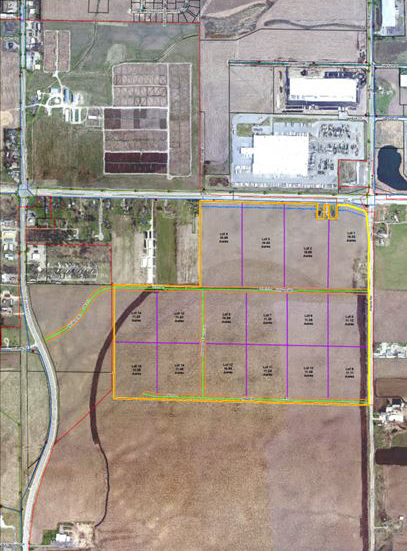
Ownership– Entire 224-acre site owned by City of Janesville
Master Site Plan – And/or site plan illustrating exact dimensions and number of parcels for the specific site being submitted for certification
- Buildable acreage: 224-acre contiguous, regular-shaped plot
- Master site plan of Highway 11 Business Park submitted – conceptual site parcels delineated with acreages
Roadway access
- Site fronts Hwy 11 to the north (4 lane) and County Rd. G/Beloit Ave. to the east (2 lane)
- ~2 miles to I-39/90 via Hwy 11E (I-39/90 will reportedly be expanded to 6 lanes over the next 6 years; during construction County Rd. G on eastern site boundary will be widened to 4 lanes)
- ~.5 mile to Hwy 51 via Hwy 11W
Rail Access
- Not applicable
Commercial Airport Access – Access to airport(s) with commercial air service
- ~3 minute drive to Southern WI Regional Airport in Janesville, general aviation and cargo service only
- ~50 minute drive to Dane County Regional Airport via I-39/90N
- ~50 minute drive to Rockford International Airport via I-39/90S
- ~1.5 hour drive to Mitchell Field via I-39/90S to I-43N
- ~1.75 hour drive to O’Hare International Airport via I-39/90S
Freight Airport Access – Access to airport(s) with freight air service
- ~3 minute drive to Southern WI Regional Airport in Janesville – primarily cargo service
- ~50 minute drive to Dane County Regional Airport – FedEx cargo service
- ~50 minute drive to Rockford International Airport – primary cargo airport serving Janesville
Water / Electric Utility Infrastructure – Proximate electric power infrastructure availability and capacities
- Alliant Energy & WI Power and Light serve site – 600MW combined-cycle natural gas power plant between Janesville and Beloit
- Venture Substation ~.5 mile NE of site is fed by 138kV ATC transmission line ~2,500 ft. from eastern site boundary; 25MVA transformer with current peak load of 7.5 MVA; serves the Hwy 11 BP via a 12kV distribution line that is heavily loaded
- Venture substation was built with 5 bays, 2 of which are occupied
- Tripp Substation ~.3 miles west of site along Hwy 11 has a 33 MVA transformer with current peak load of 12 MVA
Water / Wastewater Infrastructure – Proximate water and wastewater infrastructure availability and capacities
- Water: City of Janesville operates 8 wells in the south zone, where site is located
- Rock River Basin aquifer: 32 MGD total system capacity, average 12 MGD, peak of 18-19MGD
- 16” 80 psi main runs along northern boundary of site along Hwy 11; Separate 16” main runs along Hwy 51 west of site; both of these lines have existing available capacity for a new user
- Wastewater: 21” gravity sewer main runs along northern site boundary along Hwy 11, running west to wastewater treatment plant ~2.3 miles west of site at Rock River; the plant is permitted to treat up to 21 MGD (2011 peak usage of ~13 MGD)
For More Information Contact;
Madison Region Economic Partnership
Michael Gay
615 E. Washington Avenue
P.O. Box 71
Madison, WI 53701-0071
Phone – 608.443.1953
michaelg@madisonregion.org
www.madisonregion.org

Related Posts
-
MAINE: Yankee Ingenuity
-
ARKANSAS: When You’re in Arkansas, You’re in Good Company
-

TEXAS: Made in Texas
-

MISSOURI: Why Missouri?
-

Explore Development Opportunities in Massachusetts
-

Cape Fear Region, North Carolina
-
Calvert County, Maryland
-

St. Tammany Economic Development Foundation
-

Town of Charlton, Massachusetts
-

A Q & A with Eyal Eliezer, Head of Strategy, Invest in Israel


