


White Pine Commerce Park
26 Sep, 2013
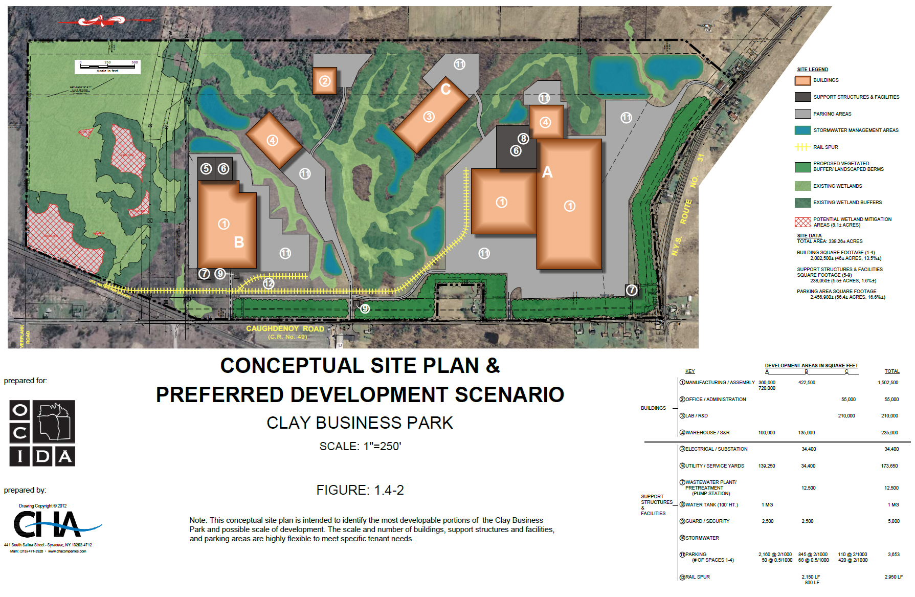
Located in central New York just north of Syracuse, White Pine Commerce Park is the largest publicly controlled industrial park in the region. The 339-acre site provides easy access to all East Coast markets, with rail-line service to the site and a major interstate within 2 miles. A deep-water port within 35 miles serves as a gateway to the St. Lawrence Seaway and Port of Montreal. Connectivity is not an issue at White Pine—the National Grid substation adjacent to the site can support multiple 115kV circuits, and telecom offerings include OC3 fiber and broadband service.
White Pine is south of Lake Ontario and is part of New York’s Finger Lakes region, so there’s ample fresh water—up to 8 MGD—available onsite for data-center cooling and precision manufacturing. It’s a stable, low-risk environment with a traditional 4-season climate, reducing the chance that a natural disaster will disrupt business. The region boasts a skilled, well-educated workforce. 77,000+ high school graduates over the age of 25 live within 10 miles, and one-third of the available workforce holds a bachelor’s degree or higher. Six nationally ranked colleges and universities offer onsite worker training and certification programs, as well as proven R&D and product commercialization assistance. For detailed information on incentives and the region’s pro-growth attitude and pro-business strategy, contact Linda McShane, Project Development Specialist, at 315-435-3770 or lmcshane@ongov.net.
Key Site Features:
LOCATION
| Highway | I-81 is located 2.2 miles to the east; I-90 is 10 miles south, via I-81 |
| Airport | Syracuse International Airport is 9 miles southeast, via I-81 |
| Deep-Water Ports | Port of Oswego, gateway to St. Lawrence Seaway and the Port of Montreal: 34 miles; Port of Albany: 145 miles; Port of New York: 280 miles |
| Rail | CSX Rail to Montreal, Dewitt Terminal. Dewitt Class 1 Intermodal Terminal: 15 miles (service: N-Montreal, S-NYC, E-Boston and W-Chicago) Address 5171 Route 31 |
| Zip Code | 13041 |
| Latitude/Longitude | 43.186664 North/76.16218 West |
| Municipality | Town of Clay, Onondaga County, New York |
| Regional Population | 467,000 |
| Distance to Major Metros (miles) | New York City: 260; Rochester: 90; Buffalo: 150; Philadelphia: 300; Boston: 315; Toronto: 240; Montreal: 240 |
GENERAL CHARACTERISTICS
| Size | 339 acres |
| Topography | Generally flat, 400’ to 425’ across the site |
| Former Use | Vacant farmland |
| Dimensions | 5,913 (west boundary) x 2,593 (north boundary) |
| Zoning | Industrial (I-2) |
UTILITIES
| Electric | Highly reliable, multiple 115kW lines to the site. Primary substation is adjacent to the site. |
| Gas | 19 psi gas line along western boundary. High-pressure gas distribution line located 9,800 feet west of the site. |
| Water | Ample Lake Ontario water. 10” water main located along west boundary. 12” main along south boundary. 3,700 gpm at 20-psi can be delivered east of the site. Access to the 54” main distribution line available, up to 8 MGD. |
| Sewer | Plans under way to construct a line to the Oak Orchard Treatment Plant, 3 miles from site. Oak Orchard capacity: 10 MGD design, 6.1 MGD average, 24 MGD peak. |
| Telecommunications | Fiber, DSL, wireless broadband available from multiple providers (Verizon, AT&T, Time Warner, T-Mobile and others) |

Related Posts
-
MAINE: Yankee Ingenuity
-

ARKANSAS: When You’re in Arkansas, You’re in Good Company
-

TEXAS: Made in Texas
-

MISSOURI: Why Missouri?
-

Explore Development Opportunities in Massachusetts
-

Cape Fear Region, North Carolina
-

Calvert County, Maryland
-

St. Tammany Economic Development Foundation
-

Town of Charlton, Massachusetts
-

A Q & A with Eyal Eliezer, Head of Strategy, Invest in Israel


