

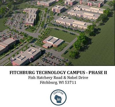
FITCHBURG TECHNOLOGY CAMPUS
11 Feb, 2015
Street Address |
Fitchburg Technology Campus – Phase II |
City |
Fitchburg |
County
|
Dane County |
Type of Space |
Industrial |
Min Size |
56 acres |
Max Size |
56 acres |
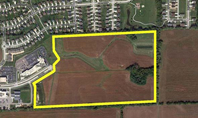
Master Site Plan – And/or site plan illustrating exact dimensions and number of parcels for the specific site being submitted for certification
- 56 acre development features 23 developable acres remaining:
- Lot 1: 1.61 acres (70,266 sq ft)
- Lot 2: 1.50 acres (65,316 sq ft)
- Lot 3: 1.69 acres (73,649 sq ft)
- Lot 4: 2.56 acres (111,301 sq ft)
- Lot 22: 4.79 acres (208,667 sq ft)
- Lot 23: 4.75 acres (206,726 sq ft)
- Lot 25: 5.93 acres (258,370 sq ft)
Ownership – Entire site must be wholly controlled by a single owner with documented willingness to sell to an industrial user
- Owned by Ruedebusch Development (Carl, CEO, very knowledgeable)
- All controlled by Ruedebusch
- Certificate of Title submitted
Roadway access
- South on Fish Hatchery Road from 12/18 South Beltline interchange. About 3.5 miles of good street access to the Beltline along commercial strip (mostly 4 lane)
- 10.5 miles along 12/18 Beltline to I-94/39 interchange to the east
- Access to the park is high-quality, well lit, and easily services the park
- New US 14 interchange opened in 2014, providing access from the east
Rail Access – If applicable / not required
- Not applicable
Commercial Airport Access – Access to airport(s) with commercial air service
- Dane County Regional Airport on northeast side of Madison is 12.1 miles from the site (through Madison) and 17 miles from the site (around Madison) – less than 30 minutes in traffic (12/18 to US 51 north)
- About 1.5 – 2 hours to Milwaukee Mitchell (90 miles)
- About 2.5 – 3 hours to O’Hare
Freight Airport Access – Access to airport(s) with freight air service
- Same as above
- Dane County Regional proposed as most useful for freight service from this location
Electric Utility Infrastructure – Proximate electric power infrastructure availability and capacities
- ATC controls transmission and substations, MG&E controls distribution (and also owns generation assets)
- 8-10 MW capacity available to the site today from two separate substations
- ~1 mile SW to Oak Ridge substation served by 138KV transmission line and 2 37 MVA transformers; ~50% capacity; underground distribution to site
- ~3 miles NE to Syene Road Substation served by 138KV transmission line and 2 37 MVA transformers; ~50% capacity; aerial distribution to site
- 13.8kV transmission line with 8 MW capacity runs to SW corner of site
- All underground service in the park
- Coal, gas, wind, and some co-gen generation. Mostly coal, but new is gas or wind
Natural Gas Infrastructure – Proximate natural gas infrastructure availability and capacities
- 4” 60 psi line at Noble Drive entrance
- Mostly just using for building heating (though Promega uses some)
- Another 2” line along the north residential border area
Water and Wastewater Infrastructure – Proximate water and wastewater infrastructure availability and capacities
- Water: 10” ~20 psi main at western site boundary and 8” ~20 psi main at northern site boundary are available to serve the site; both will be looped
- Total system pump capacity is 6.9 MGD; current peak day demand is 4.2 MGD
- 1,200 GPM water well serves the area; 500K gallon water tower serves the park (gravity fed in park); total system storage capacity is 2.25M gallons, currently ~60% utilized
- Wastewater: 10” main stubbed at NW corner of the site, 8” main stubbed at northern site boundary; these two lines will be looped to connect the broader system, but the configuration is flexible
- Site served by Woods Hollow Interceptor, available capacity of 720 GPM (peak)
Contact Information
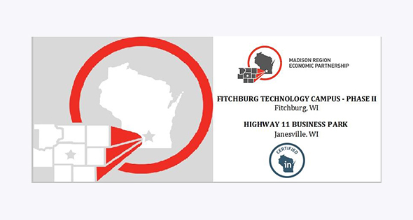
Madison Region Economic Partnership
Michael Gay
615 E. Washington Avenue
P.O. Box 71
Madison, WI 53701-0071
Phone – 608.443.1953
michaelg@madisonregion.org
www.madisonregion.org

Related Posts
-
MAINE: Yankee Ingenuity
-
ARKANSAS: When You’re in Arkansas, You’re in Good Company
-

TEXAS: Made in Texas
-

MISSOURI: Why Missouri?
-

Explore Development Opportunities in Massachusetts
-

Cape Fear Region, North Carolina
-
Calvert County, Maryland
-

St. Tammany Economic Development Foundation
-

Town of Charlton, Massachusetts
-

A Q & A with Eyal Eliezer, Head of Strategy, Invest in Israel


